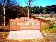

The trailhead in Smith Flat |
The El Dorado Trail is a walking, bicycle and horse trail being developed on the old Michigan-California Railroad route, on which lumber was transported from Michigan-Cal Lumber Co. in Camino to the train station that used to be located on Mosquito Road just north of Highway 50 in Placerville (now a park & ride station).
• Trail Map - El Dorado Hills to Camino
• Trail Map - Placerville to Pollock Pines
The first 2 miles of this corridor run between Mosquito Road and Jacquier Road in Smith Flat, where a new trailhead has been developed, extending the trail east over Highway 50 and connecting to another 4 miles of trail into Camino.
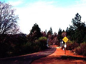
Most of the path is nicely paved with a broken center line and various traffic signs. Our favorite is the "Narrow Bridge" sign by the Schnell School Road overcrossing.
A new section of paved trail runs from Forni Road between the County Office Complex and Jail to Missouri Flat Road in Diamond Springs. One highlight: It crosses Weber Creek on the original railroad trestle bridge.
In our opinion, the first section of the trail (from Mosquito Road to across Hwy. 50) tends to be more scenic, especially in spring and fall. But the newer section does have the trestle bridge. Why not try them both and find your favorite!
The Trail at Dimity Lane in Spring |
The goal is for the completed trail to link South Lake Tahoe with the Sacramento Valley region, via the National Pony Express Trail Route and the proposed Sacramento-Placerville Rail Trail.